
By Mimi Whitefield
Miami Herald
WWR Article Summary (tl;dr) Using an application developed by “Mapillary”, a company based in Malmo, Sweden, mapping experts and volunteers stretched out across cuba to capture images of the island. The images were uploaded and stitched together by Mapillary’s machine-vision technology to create 3-D ground-level maps that show the city in remarkable detail.
MIAMI
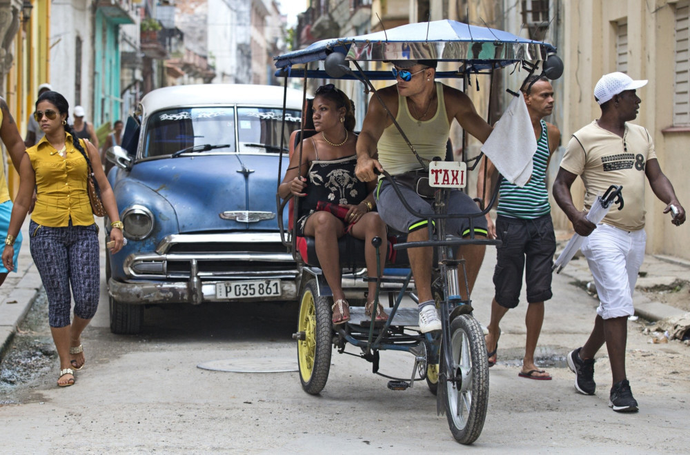
Mapping experts and local volunteers fanned out across Havana recently, recording ground-level images of cobbled streets, major thoroughfares, bus routes and plazas in the Cuban capital to create navigable, street-level 3-D photo maps.
For four days in late September, the group walked, drove and bicycled around Havana, using selfie sticks, smartphones and action cameras to record as many images as possible of the city’s 280-square-mile area. Among the landmarks that were mapped were the Plaza de Armas, the Cathedral of Havana, part of the Colon Cemetery, the Plaza of the Revolution, El Morro fortress and Estadio Latinoamericano.
Then using an application developed by Mapillary, a company based in Malmo, Sweden, the images were uploaded and stitched together by machine-vision technology to create 3-D ground-level maps that show the city in remarkable detail and are available to the public for free.
“We use a little bit of magic to transition nicely from image to image,” said Jan Erik Solem, Mapillary’s founder. He previously launched Polar Rose, a facial recognition software company that Apple acquired in 2010.
The mapping team, which included a Mexico-based Mapillary executive and 11 members of Cuba’s open street map community, recorded 140 gigabytes of data. Mapillary began uploading the Cuban images to its site on Sept. 26.
Solem said the photo maps will always be available to individuals for free. The company makes its money by selling the information to mapping companies and other commercial entities, which also are asked to contribute to the platform.
The mappers were able to record far more than the layout of streets because they could go to areas not accessible by car such as plazas, parks and gardens.
On foot and using a car and two motorcycles, the mappers covered more than 217 miles. During the four days, they managed to photograph about 60 percent of Cuban public transit routes, about 90 percent of Old Havana, parts of Miramar and Vedado, and the primer anillo, the highway around Havana.
They also ventured outside the city recording footage at the Church of San Lazaro in El Rincon and Ernest Hemingway’s home, Finca Vigia, which is about 10 miles east of Havana in the town of San Francisco de Paula.
The Mapillary platform allows users to see landscapes change in real time. Because of Cuba’s spotty internet connectivity, the team took most of the photos that were captured in Cuba to Mexico to complete the process.
Some areas where Mapillary took pictures required permits and fees like El Morro, but for the most part, the volunteers captured images in public places that required no special permission, said Claudio Cossio, Mapillary’s Mexico-based head of Latin American user growth. He was part of the Havana mapping team.
The mappers were a bit apprehensive about how the project would be received. “Open data isn’t currently legislated in Cuba. It’s kind of a gray area,” Cossio said after returning to Mexico.
“Crowdsourcing is not well-known in Cuba, so we wanted to tread lightly because some government organizations might not be in favor of this type of initiative,” he said. “We didn’t run into any problems.”
Although some of the mappers were using 360-degree cameras, they tried not to call attention to themselves. Instead of mounting cameras on the roof of the car, for example, all the images were recorded from inside the vehicle. And the citizen mappers were told not to do anything illegal, not to take pictures in restricted national security areas and to respect people’s privacy.
Before images are released to the public, faces and any visible license plates are blurred.
Cossio said the last time the cartography of Havana was updated was 1955. “Or if it has been updated, citizens haven’t had access to it,” he said. The hope is the Havana project will kick-start mapping in Cuba and it will spread to cities throughout the island, Cossio said.
Mapillary left some of its equipment in Cuba so the volunteer mappers could continue capturing images; the company hopes to return to the island next year.
Cuba’s open street map community did some preliminary mapping near Havana’s Cerro neighborhood before the project began, although it didn’t use a 360-degree camera like those employed in mapping exercises in Sweden and for some of the recent Cuban mapping.
Since its founding in late 2013, Mapillary has been used to map more than 1.2 million miles with 84 million pictures in cities and rural areas around the world. The goal is to eventually create a crowd-sourced representation of the entire world.
Because Mapillary is a real-time platform, it can help governments and organizations deal with infrastructure problems more quickly. In Cuba, for example, maps of the streets of Old Havana, which are often difficult to navigate, might be used by projects to help the visually impaired and those with mobility challenges, Cossio said.
Mapillary hopes the maps it produces will be useful to the Havana government as well as to Cuban entrepreneurs and other individuals. “The tech community in Cuba is centered on tourism and in tourism, maps play a big role,” Cossio said. There are already several tourism and dining apps that have been created by Cuban entrepreneurs.
Among the global users of Mapillary is the World Bank, which is employing the technology in a project designed to create accurate maps of the most flood-prone areas of Dar es Salaam, Tanzania, one of the fastest-growing cities in the world. For the project, local residents who know their city best have been trained to record previously unmapped areas.
“Mapillary is also free for this type of work,” Solem said.
The company says beginning to map is easy and anyone can do it. It requires little more than a smartphone, although some users prefer more sophisticated cameras. Users download the app, create an account on mapillary.com and begin taking photos. Users can take pictures themselves or use an automatic mode that allows the app to take photos at regular intervals and review their pictures before uploading them.
A father and son team, for example, made significant progress mapping the remote Faroe Islands, which are about halfway between Norway and Iceland between the Norwegian Sea and the North Atlantic, during their summer vacation using three simple cameras and a smartphone.
After Faroe Islanders petitioned rival Google Street View to come and map the islands, Google arrived on Aug. 31 to begin mapping with cameras mounted on bikes, backpacks, ships, a wheelbarrow and even the backs of sheep. Some 70,000 sheep live on the islands, more than the entire population.
Google Street View’s global reach is far greater than Mapillary’s, but Solem said the Swedish company hopes to top Google’s coverage within a few years, mostly because of its growing network of community mappers.
When Google maps, it generally sends a fleet of vehicles into a city or town and then doesn’t come back and update for a few years.
“We have a different way of capturing images as well as our frequency of updating is different,” Solem said. “We offer a way for anyone to contribute and fill in (mapping) gaps.”